
QuantyUrban
Urban geological information system
- No.
- URBAN
- Lineage
- Built on QuantyView 3.0
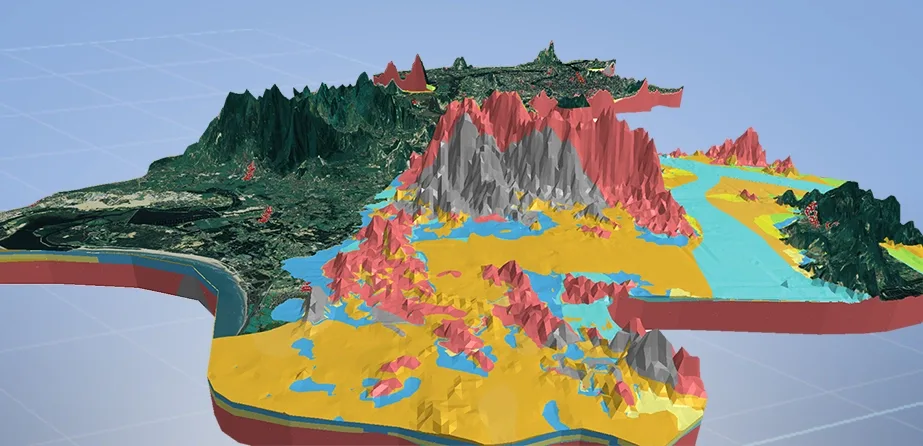
Urban geological information system
Built around a theme-based object-relational urban geological database, the system collects and integrates data from different periods and departments, including all kinds of borehole and test records: regional geology, engineering geology, hydrogeology, geochemistry, environmental geology and geological hazards, geological resources, geophysical exploration, remote sensing geology and basic geography. It gives government decision-makers, specialists and the public geological visualization tools and an application service platform.
It provides integrated data management, mapping, analysis, assessment and decision support for urban planning, groundwater management, geothermal use, geological hazard surveys, geological environment assessment, seawater intrusion assessment, site selection for key projects, underground space use, underground engineering design and other studies.
Its development was funded by the China Geological Survey, the Nanjing Institute of Geology and Mineral Resources and the Fujian Institute of Geological Survey, and it has been continuously developed and refined through real use in Nanjing, Fuzhou and other cities.
The system has three subsystems: data management, information processing and information services.
The geological data management subsystem consists of raw, basic and results databases with their data entry and management modules. The raw data module stores and manages the original records obtained directly by instruments, laboratory analysis or field observation during urban geological surveys. The basic database stores and manages all borehole data organized to standards, together with related test, analysis and testing data. The results module stores and manages results produced by conversion, analysis and processing, including newly compiled result maps and assessment reports.
The geological information processing subsystem consists of 2D geological map compilation, 3D visual geological modelling, and 3D geological analysis and assessment modules. Combining structured and parametric approaches, the 2D compilation module drafts, queries, edits and prints all conventional geological maps to professional standards. For the Fuzhou urban geological survey it also provides thematic maps such as contour maps, crustal stability assessment maps, geological hazard risk assessment maps and integrated hydrogeological maps.
Combining knowledge-driven modelling with section topology reasoning, the 3D visual geological modelling module builds fast, dynamic, holographic and fine-grained models of the study area's complex geological structure:
Based on Boolean operations, vector cutting and geostatistics, the geological spatial analysis and assessment module provides spatial analysis, simulation and assessment functions: virtual excavation, dynamic sectioning, fence diagrams and dynamic simulation of certain processes. For example, it can simulate a metro tunnel excavation, show excavation progress and fly through the ground along the construction route to see the strata and structures the works will meet. Where soft soil or quicksand is encountered, foundation stability can be analysed; where pipelines are encountered, their diameter, material and owner can be checked for construction safety analysis, supporting decisions on pipeline avoidance.